
Weekend Read: Viewpoint & Experience of the Glacial Grooves in Mediated Representation: an Embodied Point of View
A historical treatment of imagery and why a model doesn't evoke the same sense of awe as seeing it first hand.

The photogrammetry project I am developing around the glacial grooves at Kelleys Island can be misread as a contemporary intervention. It relies on tools that feel new: dense image capture, computational alignment, statistical surface modeling, and three dimensional reconstruction in mesh models that approximate the surface. The outputs look unfamiliar to many viewers, particularly when compared to conventional landscape photography or documentary images of geological sites. Yet the underlying impulse is not new. From the earliest days of photography, these grooves have repeatedly demanded technical responses precisely because they resist ordinary representation by being exceptionally difficult to capture in replicable media in any meaningfully realistic way.

From drawing to engraving, to texts, reports, and lectures, to early photography then serial stereography, and to my mesh model, every attempt fails to capture the immersive nature of these geologic features on this tiny island in the Lake Erie Archipelago. As I work on completing my manuscript about the glacial landscapes of the Great Lakes (part of my archive record at Nevada Museum of Art), I have followed the development of approaches to documenting complex sites like these grooves, and after recently posting my mesh model of the grooves, I want to contextualize it in the lineage of approaches that inform my model, and also put some emphasis on the ways other modes of representation have succeeded and failed at capturing the sense of awe that sites like this evoke when we encounter them spatially with our actual bodies.
This project sits within a lineage of visual practices that stretch back to the nineteenth century, when the grooves were first being systematically documented at the same moment they were being destroyed by quarrying. The tools have changed, but the problem has not. How does one record a landscape whose significance lies in scale, continuity, and subtle curvature, rather than in isolated features or picturesque views? And how does one preserve knowledge of such a landscape when the physical site itself is under active erasure?
The earliest sustained attempt to address this problem can be found in the stereogram cards produced by A.C. Platt in the 1890s. These images, made as industrial extraction accelerated, represent one of the first technical efforts to convey the grooves as three dimensional phenomena rather than as flattened curiosities. They were not souvenirs in the casual sense. They were instruments of seeing.
Stereography and the Problem of Geological Scale
By the time Platt produced his stereograms, stereoscopic photography had already established itself as a powerful visual technology. It offered something conventional photography could not: the ability to suggest depth through binocular vision. When viewed through a stereoscope, paired images taken at slightly different angles created a convincing illusion of volume, allowing viewers to perceive spatial relationships directly rather than infer them from pictorial cues.
For geological subjects, this mattered enormously. Glacial grooves do not announce themselves easily in single images. Their significance emerges through continuity, repetition, and subtle variation across large surfaces. When reduced to a flat photograph, they risk appearing decorative or incidental. Stereography offered a way to restore some portion of their spatial reality.
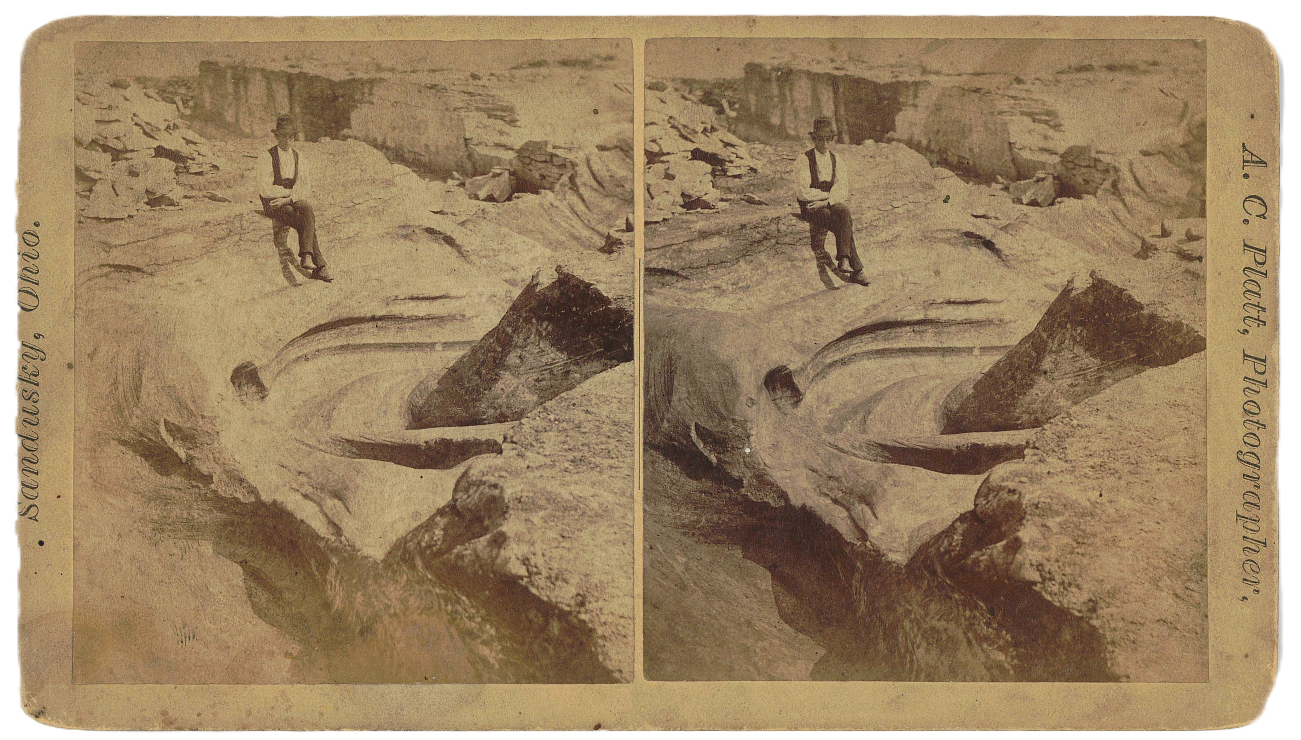
Platt’s cards frequently place the viewer at oblique angles to the grooves, emphasizing their length and curvature. The quarry walls and industrial scars are often visible, sometimes intruding directly into the frame. These are not neutral documents. They show a landscape in transition, one being actively dismantled even as it is being recorded.
The timing is critical. In the 1890s, glacial theory in North America was still consolidating its authority. While European scientists had advanced models of continental glaciation earlier in the century, American acceptance came more slowly and relied heavily on field evidence that could be communicated beyond isolated sites. The grooves at Kelleys Island were not just local curiosities. They were persuasive objects.
From Stereogram to Engraving
The stereograms did not remain confined to private viewing devices. They circulated, directly and indirectly, into scientific publications through engravings derived from the stereogram photographs themselves. At the time, commercial printing was unable to reproduce photographs at scale, so for a few short years in the late 1890s, photographs were converted into engravings before printing. These engravings are often misunderstood today as purely illustrative or interpretive. In fact, they functioned as translations between media, each with its own constraints and affordances.
Engraving allowed images to be reproduced at scale in journals and books, but at the cost of depth cues, tonal subtlety, and precision of micro-surface variations in the depicted object. To compensate, engravers emphasized line, directionality, and contrast. The grooves were rendered as insistent parallel striations, their continuity exaggerated to ensure legibility on the printed page, but even still, some shops produced better engravings than others and in another post I’ll demonstrate why certain engravers carved better grooves (both at the formal depictions of geologic grooves and functional ink-holding grooved plates for printing). These engravings filled the academic texts of the 1890s and craft fidelity determined the quality of the data that geologists around the world were using to understand new theories of continental glaciation.
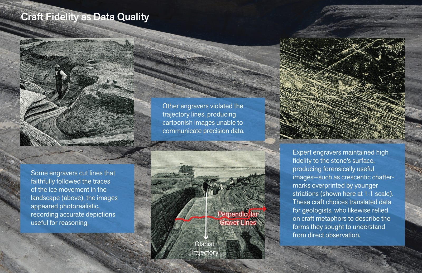
As one of the chapters in my book manuscript shows, this process mattered for enabling the theory of continental glaciation to gain a foothold in geologic and public discourse in the early 1900s. These images helped stabilize the grooves as evidence of glacial motion rather than as isolated erosional anomalies or as simple results of flooding at scale. Directional markings became arguments. Repetition across surfaces became proof. The visual language of engraving shaped how the grooves were understood, discussed, and taught, and for that matter, shaped how people came to “believe” in glaciers as agents.
Importantly, the engravings often abstracted the site away from its industrial context. Quarrying receded or disappeared entirely, replaced by idealized surfaces that could stand in for glacial action itself. In this way, the images participated in a selective preservation of knowledge. They saved form while losing context.
Loss as a Condition of Documentation
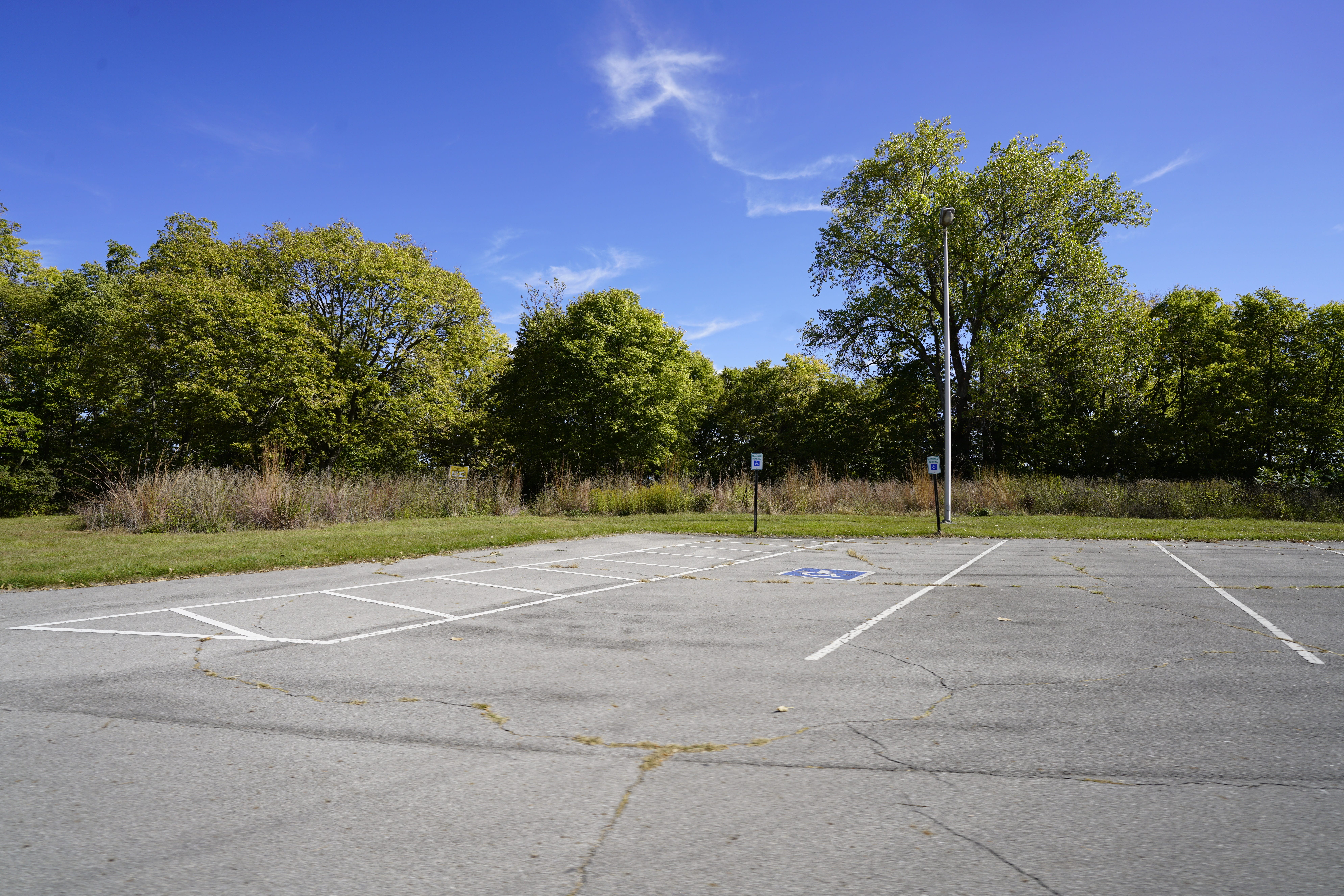
Platt’s stereograms and the engravings derived from them exist because the grooves were being destroyed. The act of documentation was already entangled with loss. This is not incidental. It establishes a condition that persists into the present. This past field season I built a stereoscope pinhole camera and visited the sites Platt documented, oriented myself by aligning with landmarks and horizons and recreated some of his images.
My images were taken in the precise location of Platt’s images, only instead of geologic features, most of my images captured various views of the parking lot that sits where the great central groove used to be and the public boat launch where the loading dock used to be. I haven’t developed the paper images yet, but here’s a digital image of that parking lot with an individual tree that appears in Platt’s photos with similar crown shape (I measured the base at more than 9 feet around):
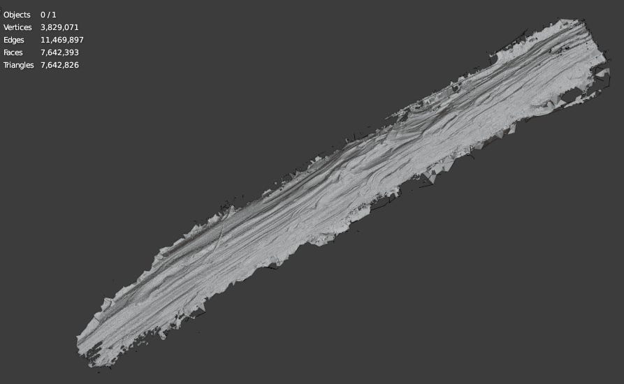
My photogrammetry project was able to document the section of grooves that was preserved, but it comes out of a similar tension of dealing with loss. The grooves that remain are fragmented, fenced, weathered, and isolated from their original continuity. What survives does so under protection, but also under constraint. No single vantage point allows the viewer to apprehend the site as it once existed. Visitors are required to remain on the trail that surrounds the site and to not enter the site itself. The landscape must be reconstructed mentally, or technically.
Photogrammetry offers one such reconstruction. By assembling hundreds or thousands of overlapping images, it produces a composite surface that no individual photograph can capture. For this model I used 11,000 photographs that I captured with a DSLR in, around, and through the site. Like stereography, it relies on the relationship between images rather than on any single frame. Depth emerges from correlation.
I’m reminded of Hockney’s Walking in the Zen Garden (and indeed all of his multi-perspectival images) which points out the fact that composite images are also composites of multiple perspectives. He describes it this way:
“For Walking in the Zen Garden, I took more than 160 photographs...it was then and only really then that I began to realize that one of the areas I was really examining was perspective, that this was what you could alter in photography. When I first pieced them together I thought I had made a photograph without perspective.” (Hockney, 2004, 101).
I think about this quote a lot as I build composite images, especially when I’m trying to decide what perspective an image presents. Stereoscopic images combine two perspectives. Photogrammetry combines as many perspectives as there are source images, and then computes the perspectives that might be missing. Inherent to a photogrammetry image is the density of perspective so much that new perspectives not supplied in the data can be found inside the composite by the strange eyesight of calculation.
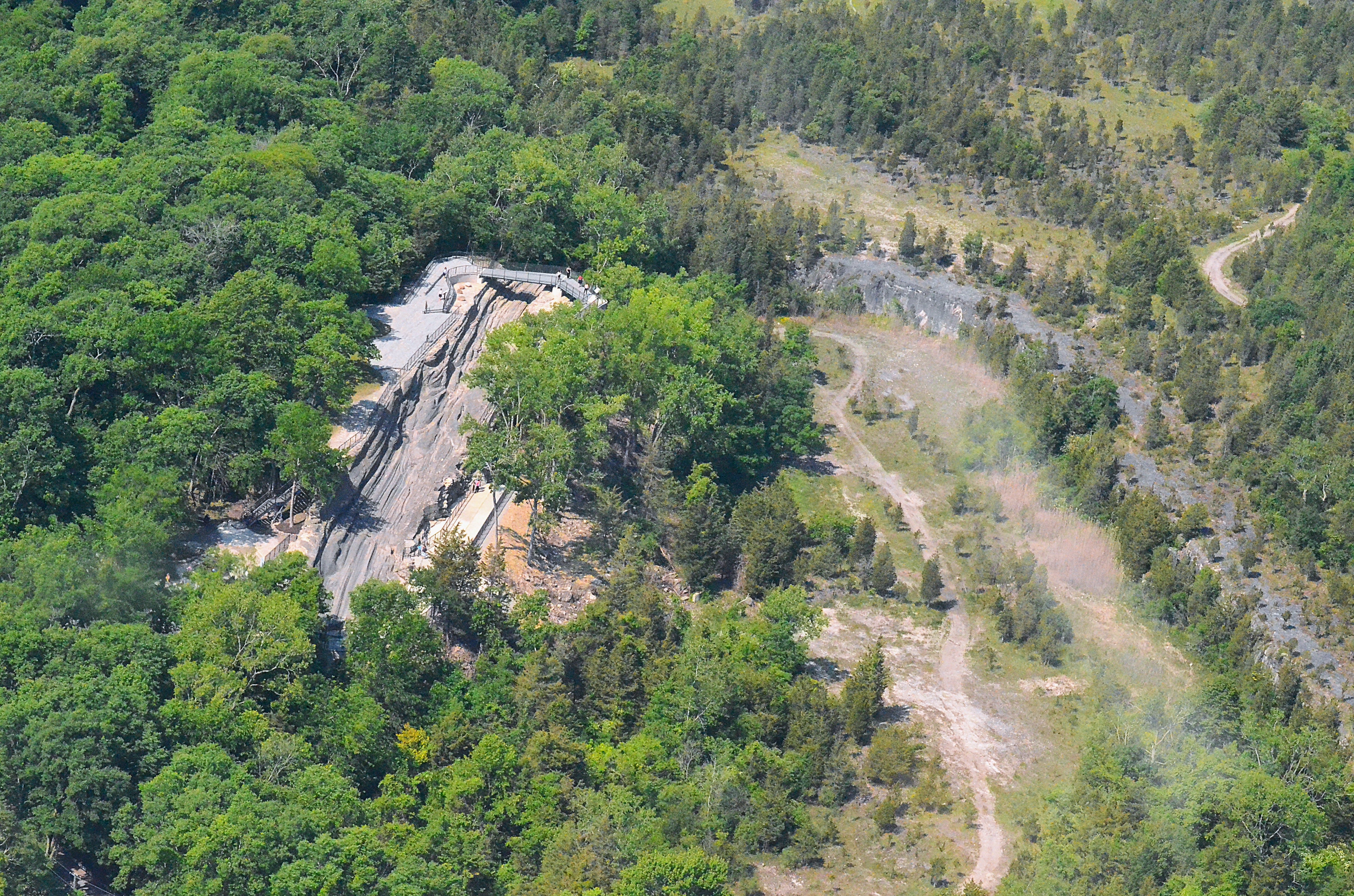
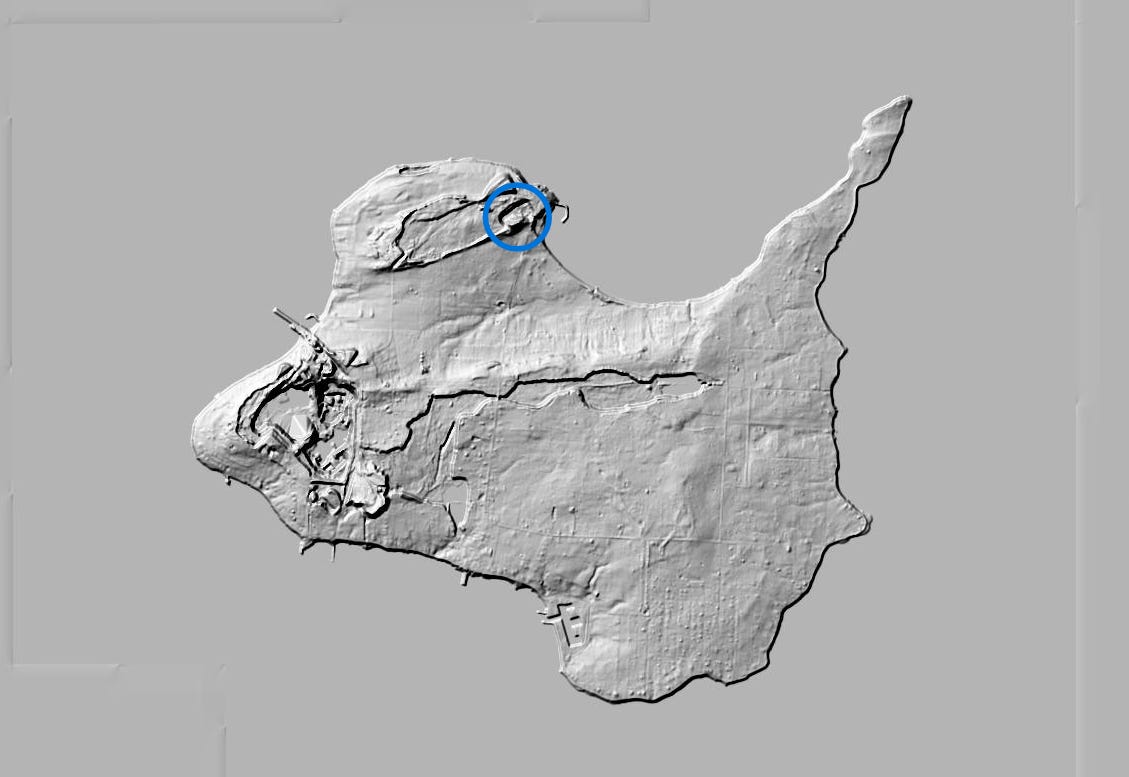
Yet photogrammetry is not a simple technological upgrade from stereoscopic imaging. It is simply a continuation of an old problem addressed with new means, and it’s not even state of the art. LiDAR gives a far more precise reading, but at the time I captured these images, I did not have access to a LiDAR rig. There are public datasets of hillshade produced with LiDAR, but the granularity is insufficient to capture the types of details I was able to capture with photogrammetry. Below is a hillshade image of the island. The center of the blue circle contains the same landscape pictured in the aerial photo I took of the grooves and quarry. This gives a sense of the disproportionate granularity between my high resolution mesh model and the low resolution open LiDAR data.
Photogrammetry also diverges from the mediated embodied experience that stereograms provided. Where stereograms asked the viewer’s eyes to perform the work of synthesis, photogrammetry delegates that task to software. Likewise, where engravings emphasized line to preserve legibility, statistical surface models emphasize deviation and variance.
In each case, the goal is not realism in a naive sense. It is legibility under constraint.
Mediated Participation & First-Person Photogrammetry
The visual model of the glacial grooves is the closest I can come to giving someone access to the experience of physically being inside the grooves at the site, but I would be hard-pressed to call the model “immersive,” as I’ve heard it be so called. My hesitation to use that word comes from an experiential hesitation and also a technical one. Experientially, I know nothing compares to being on site. Technically, I know the models more closely depict spectatorship than enabling the participant viewpoint required for something to be veridically immersive.
In my broader research on viewpoint as a tool, I have focused on how attention can be modulated through orientation and disorientation. I am especially interested in the way oscillation of viewpoint amplifies cognitive effect. When a viewer is repeatedly repositioned between participant and spectator roles, their understanding of a site becomes less stable and more engaged. The mind works harder to reconcile scale, position, and meaning.
These visual models are the closest we can get to giving people the experience of being a participant immersed in the site itself. But this is not true participant viewpoint; it is mediated participation which actually makes it a kind of spectatorship. This experience of being removed from the scene itself turns it into a kind of voyeurism.
Oscillation between participant viewpoint and spectator viewpoint increases cognitive effect by modulating attention patterns toward orientation or disorientation.
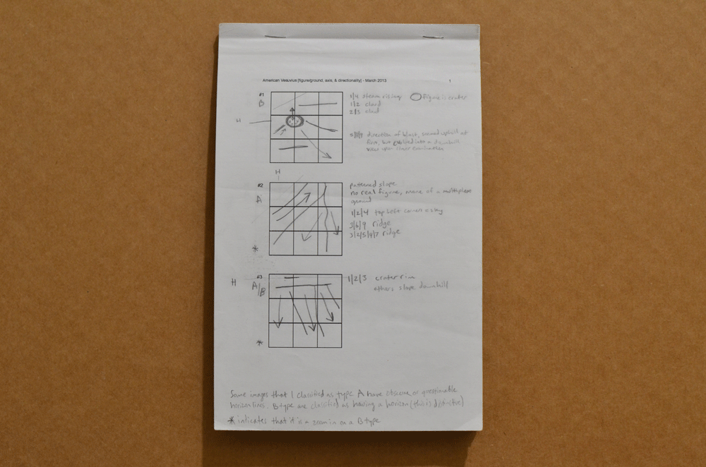
One of the clearest examples of this oscillation at work appears in Barbara Tannenbaum's curation of Frank Gohlke & Emmet Gowin's photography of the aftermath of Mount St Helen's eruption in American Vesuvius (2013) at the Cleveland Museum of Art.
When I studied that exhibition, what stood out was not any individual image, but the rhythm produced by their sequencing. Ground level photographs, taken from within the devastated landscape, were interspersed with aerial views that pulled the viewer abruptly upward and outward to look down onto the scenes. The sequence of how the photographs were hung in the gallery bounced back and forth between spectator and participant viewpoints, rhetorically structuring the experience to perform the experience of confusion and overwhelm of the eruption aftermath.
To prove the cognitive grounding of this effect, I diagrammed the composition of each photograph in the exhibition and analyzed the sequences with cognitive framing, which solidified a formal model of understanding how the sequence of viewpoint switching structured the textural experience of encountering exhibition rhythms. I’ve published about this research in the landscape architecture journal KERB (RMIT) and in my book with Punctum, so I won’t get into that here, but I do want to share these sketches I made during my analysis of the exhibition so you can see the general way I analyze motion and measure attention in visual composition:
As viewers walked through the exhibition, the photographs they saw switched back and forth between immersive participant viewpoints to distal/removed spectator viewpoints to accumulate a cognitive effect of disorientation. But in my mesh model of the glacial grooves, there is no switching viewpoints. The camera fly through is from the immersive participant viewpoint, but your encounter is through mediated participation. It is an approximation only (like any digital twin or any virtual reality or augmented reality encounter). This isn’t an argument against digital twins or AR/VR. Those technologies give a kind of completeness needed for coordination across systems at scale, but they don’t replace the experience of a human body being human during a human experience of an encounter with a site, which is where I believe the magic happens.
The model cannot be a substitute for being in the site itself. Viewing the model is an abstraction of immersion, and it can’t be anything other than spectatorship. You have to be there to get the participant viewpoint, because then your body has the experience of immersion, and not just your brain.
Platt’s stereograms function the same way as individual images, they give a sense of immersion through simple stereovision, but the view is removed from actual stimulus, it is a depiction and a representation.
Looking through the sequences of images Platt captured, there is a path movement through the site, ambling in and out of grooves, across the quarry floor, around the perimeter to get a better look at views we can’t take today because the subjects were quarried away over a century ago. One has the sense of participation in the scene, but only because of accumulation, not because of phenomenology.
Contemporary Tools, Historical Continuities
There is a tendency to frame contemporary imaging technologies as fundamentally novel. Three dimensional models, point clouds, and algorithmic reconstructions are often presented as breaks from historical practice. In reality, they belong to a long tradition of technical vision, particularly within the sciences.
The nineteenth century was filled with experiments in visual approximation. Photography itself was not immediately accepted as objective. It required conventions, standards, and interpretive frameworks. Stereography was one such experiment, promising access to spatial truth while introducing its own distortions.
My project does not claim to resolve these tensions. Instead, it makes them explicit. The photogrammetric models I produce are not substitutes for the grooves themselves. They are artifacts, shaped by choices about resolution, camera position, and algorithmic thresholds, as well as constraints outside of my control such as the weather and the lighting. They reveal certain aspects of the grooves while suppressing others.
This, incidentally, is precisely what earlier technologies did, too. Platt’s stereograms privileged continuity and depth at the expense of surface texture. Engravings privileged direction and repetition at the expense of material specificity. Each tool made the grooves visible in a particular way, for a particular audience.
I think understanding this lineage matters as we look at digitally constructed images and algorithmic compression. It situates contemporary work within a historical conversation rather than outside it. It also reframes novelty as responsibility. To use new tools is not to escape history, but to add another layer to it. And it also reminds us that the image is not the experience, because the body isn’t present.
Toward a Cumulative Record
One of the ambitions of this project is cumulative rather than corrective. I am producing work that sits alongside the earlier works by photographers before me. My stereoscopic pinhole studies approach the task of trying to understand by recreating the earlier works with the same methods. The stereograms, engravings, photographs, and models form a record of repeated attempts to grasp the same phenomenon under changing conditions.
This cumulative approach mirrors how geological knowledge itself advances. No single observation settles a theory. Instead, understanding accretes through repeated encounters, each shaped by available tools and prevailing assumptions. It’s like the statistical image stacks I process on hundreds of stones to find the standard deviation, accumulating a good sample will yield a solid calculation which gives us good technical perspectives on the world we’re encountering phenomenologically. Theory advances with that kind of accumulated evidence.
The grooves have always demanded this kind of close attention. They evoke a sense of awe which I’ll describe in a future post about the build up of anticipation in reaching the remoteness of this site (and how I believe this contributes to their fame). They are not easily consumed. They resist the single image, the quick explanation, the isolated sample, the selfie. Their scale exceeds human bodies, and their subtlety exceeds casual perception.
That resistance is what has kept artists, scientists, and technicians returning to them for more than a century. The photogrammetry project is one more return. It is not a claim to finality, but an acknowledgment of persistence.
There is a trope in writing about the grooves on Kelleys Island, a replicated exaggeration that every brochure and website copywriter tries to phrase in their own way to avoid plagiarism (and sometimes not even that much effort). It so suspicious that I wonder if some of these writers have never seen the grooves in person. It’s the claim that the glacial grooves on Kelleys Island are “the most spectacular grooves” or “the largest glacial grooves” or “the most accessible example of glacial grooves in the world” — they aren’t. There are bedrock mega-grooves across the globe, including Canada, England, Australia, Greenland, and more, and even further beyond, there are extraplanetary occurrences showing up on Mars.
The Kelleys Island site isn’t even large enough to be classified as a mega-groove; it’s merely a groove system by accepted classification schema. There are thousands of striated sites in North America alone. In 1888 Thomas Chrowder Chamberlin reported in the seventh annual report of the US Geological Survey that 2,474 sites of glacial striation occur across the northern United States. He recognized that many people would not believe him and so he proceeded to list the names of the geologists comprising that cohort of first-hand witnesses of these sites along with the count per state. There was a lot of effort put into convincing people of the enormity of the continental ice sheet at the end of the 19th century.
But there is less interest in glacial grooves today than there was in the 1890s. In a simple Google Ngram map of the term “glacial grooves” we see the peak happened in 1894 (I know why, but I’m saving that for a different post). The chart itself resembles a cross section of grooves and shows that interest has fizzled out along the trajectory of the arrow of time; their removal from public consciousness co-extending with their removal from the landscape through quarrying:
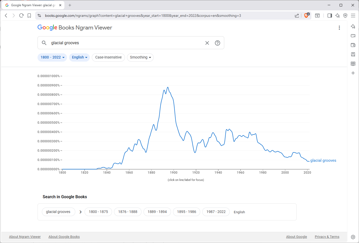
In fact, while the glacial grooves enabled the theory of continental glaciation to be derived from observation in North America in the late 1890s, the science of glaciology has largely moved on. As more than one tenured geologist has told me, glacial grooves were “solved a long time ago.” This Ngram confirms that grooves are unsexy in the literature. Still, sites like Kelleys Island remain contested about mechanisms of local formation as seen in recently published contrasting views (Newton, et al. 2018 and Munro-Stasiuk, et al. 2005), among others.
I digress.
In some of the posts that follow over the next few months, I will introduce specific examples from the historical record alongside contemporary outputs from this project. Each pairing will focus on a particular problem of representation: depth, scale, continuity, and loss. The goal is not to draw metaphors prematurely, but to establish a shared technical ground on which later interpretations can stand.
If you haven’t seen the grooves in person, and you have the means, I highly recommend taking a trip. Ferry service opens up again in March.
RYAN DEWEY
One more thing: this is not an ad, but I’m sharing because it’s relevant to people who love the grooves. I made a limited run of this fun little badge for you to sew onto your backpack:
